2.3 Environment: How is the Three Gorges Dam Interfering the Environment?
While “eliminating floods and meeting important economic and psycho political needs…Man’s creation of dams and large artifice; reservoirs constitutes an ecosystem modification on a grand scale” (Scudder, 1973, p.46). Over the years, researchers from environmental science, sociology, anthropology, psychology, and economics have done much to develop a strong knowledge-base concerning the long term implications and impacts of mega-dam modifications in different environmental zones.
The environmental impacts of the TGDP are profound, and are likely to get worse over time (Dai, 1994; Gleick, 2008; Guo, 2010). The impoundment of the reservoir has not only submerged hundreds of thousands of local culture heritages resources, but has also had a tremendous impact on the aquatic and territorial biodiversity. The submergence of thousands of factories, hospitals, abandoned mines and waste dumps discharged by massive industrial clusters upstream are creating industrial wastes and pollutants in the reservoir (Dai, 1994; Yang et al., 2006; Gleick, 2008; Guo, 2010). The increasing landslides caused by the erosion of the riverbanks in the reservoir pose a threat to the life of millions. The tremendous weight of total water in the reservoir created worries among many scientists about reservoir-induced seismicity (Dai, 1994; Crampin et al., 2006; Gleick, 2008; Guo, 2010; Zhang & Lou, 2011).
For many decades, the Chinese government has ignored warnings from geologists, biologists and environmentalists. However, all these denials have begun to give way to reluctant admittance of increasing environmental problems related to this massive dam after major western media sources began to report the accidents and threats from water pollution, landslides, increasing waterborne diseases, drought and flooding, as well as growing political unrest and social dissatisfaction associated with the relocation of 1.3 million people (Oster, 2007; Yardley, 2007; Gleick, 2008). Weng Lida, Secretary General of the Yangtze River Forum was quoted as saying “the problems are all more serious than we expected” (Oster, 2007). In September 2007, Chinese senior officials admitted that “the Three Gorges Dam Project has caused an array of ecological problems, including more frequent landslides and pollution, and if preventive measures were not taken, there could be an environmental ‘catastrophe’” (Xinhua, 2007b; quoted in Gleick, 2008, p.139; see also Bosshard, 2011).
2.3.1 Affecting Biodiversity
Conservation of biodiversity is a serious concern (Park et al., 2003; Wu et al., 2004; New & Xie, 2008). It is all too easily forgotten that unprecedented numbers and varieties of vegetation and fauna have been decimated when large areas of land which were once their homes were submerged. Along with the massive population resettlement in the reservoir area, reduction, loss and fragmentation of terrestrial habitat have become significant problems (Wu et al., 2003&2004; Lopez-Pujol & Ren, 2009). Although the whole coverage of the Three Gorges Dam reservoir is estimated to be 1,080 square kilometers, its ecological effects have been radiated to about 58,000 square kilometers (Gleick, 2008). According to a report by YWRP in 1999, this is an area which homes nearly 6,400 different species of plants, almost 20 percent of China’s total range, among which 57 represent endangered species (YWRP, 1999; Huang, 2001; Wu et al., 2003). 22 types of vegetation were threatened by the impoundment of the reservoir behind the Three Gorges Dam (Tian et al., 2007).
Other species groups threatened by the dam construction, besides the plant species include the collection of terrestrial animals which became habituated to living in the reservoir area. According to Ponseti and Lopez -Pujol, these terrestrial animals will be “forced upwards as the reservoir begins to fill, a move which will prove difficult for many species that are highly adapted to specific habitats” due to the plant stratification in this area (Ponseti & Lopez-Pujol, 2006, p.171). Research by Z. Shen in 2000 reveals that above 1700m the ecosystem contains both a deciduous and a coniferous forest (Wu et al., 2003). Between 800 and 1700m it is observed the dominance of evergreen and deciduous broadleaf mixed forests, while the area which surrounds the reservoir below 800m grows mainly evergreen broadleaf forest (Ponseti & Lopez-Pujol, 2006). For example, significantly increased intra and inter specific competition among local populations of terrestrial animals has been detected in the newly created, isolated island in the reservoir, which makes adaptation of habitat change difficult for species being forced upwards by the submersion of reservoir (Ponseti & Lopez-Pujol, 2006; Wang et al., 2009a). This changing environment process may lead to the significant demographic change of the species in the Three Gorges Reservoir Region (Wang et al., 2009a).
Habitat loss and shifting and associated environmental change caused by the dam inundation has affected not only terrestrial biodiversity, but also the community of freshwater fish in the Three Gorges Reservoir region (Wu et al., 2003; Xie, 2003; Xie et al., 2007). Chinese regard the Yangtze River as “China’s treasure house of freshwater aquatic resources” (Tullos, 2008), as there are more than 1,100 aquatic species in the Yangtze river, including 361 fish species, which counts for more than one-third of all freshwater fish species in China (Xie, 2003; Gleik, 2008). 27 percent of the total of China’s endangered freshwater fish is homed in the Yangtze River. There are 177 endemic fish species, of which 40 have already been put on the endangered list (Dudgeon, 2000; Fu et al., 2003). It is therefore especially important to realize that the Yangtze is a crucial area for preserving fish genetic resources and biodiversity, and also provides half of China’s total freshwater fish production (Xie & Chen, 1999; Tullos, 2008).
One of the major threats to fish biodiversity in the Yangtze River basin caused by the Three Gorges Dam is hydrological alterations (Fu et al., 2003). Significantly altering the flow of the river thus changes the deposition of sediment and other subtle marine eco-factors such as the chemical, sediment, and temperature composition of the water, all of which influence the balance of ecosystems and fish populations in the Yangtze (Baxter, 1977; Dynesius & Nilsson, 1994; Dudgeon, 2000; Xie, 2003; Nilsson et al., 2005). Originally, the Yangtze basin was a huge flood plain divided by a huge interconnected river network including many larger lakes which are also linked to the main channel (Xie et al., 2003). Complex flood control systems that link those channels and lakes were established to protect the urban and agricultural areas to accommodate the population increase and economic development (ibid). The construction of the Three Gorges Dam, along with another big dam – the Gezhouba Dam completed in the 1980s and located in the upstream of the Three Gorges Dam has worsened the situation by further creating restrictions of the mobility of many migrating fish species (ibid). Caused by the implementation of flood control systems in the Yangtze Basin, the resultant restrictions have in some cases blocked the migration routes of several large fish completely (Xie et al., 2003; Reynolds, 2011). The reason why this happened is that certain fish which traditionally migrate back up the River to their spawning grounds in the higher reaches of the Yangtze unfortunately find it difficult to pass the dam and therefore are unable to reproduce, thereby causing a significant decline in the species population (Zhong & Power, 1996; Zhao et al., 2008). Although some spawning fish have adapted, this is not the case for all species. The blocking of migration routes and the destruction of spawning grounds in the Three Gorges region has already severely altered many terrestrial and aquatic habitats (Brosse et al., 2003), including some of the most notable endemic fish species, such as the Yangtze Dolphin, the Chinese finless porpoise, river sturgeon, and the Chinese paddlefish (Dudgeon 1995; Zhong & Power, 1996; Chang, 2001). There are grave concerns that a range of aquatic mammal and endemic fish species could soon end up extinct, unless marine biologists are able to develop highly innovative conservation programs designed to ensure their survival (Chang, 2001; Gao et al., 2009).
In general, it has now been determined that species in the reservoir region will force to adjust to sudden loss and fragmentation of natural habitats, or they will disappear (Park et al., 2008). For example, the dam brings about a more humid microclimate, thereby attenuating traditional habitats, while increasing competition for food resources among species, thus possibly reconstructing the local food chains (Dudgeon, 2000a; Fu et al., 2003; Park et al., 2008). According to some marine biologists, such environmental transitions as these have both immediate and long-term effects, many of which are highly unpredictable (Dynesius & Nilsson, 1994; Dudgeon, 2000a; WCD, 2000).
2.3.2 Effects on local culture heritages resources and aesthetic values
The Loss of the Cultural Heritage
As the water level of the Three Gorges Dam rose, it inundated not only thousands of square kilometers of habitat but thousands of years of history as well. The Three Gorges area is one of the great sources of the historical origins of Chinese civilization. The long history of the Yangtze basin explains its archaeological importance. Some remains stretch back as far as 600,000 years ago to Neolithic times, when so-called Lantian man, a subspecies of Homo erectus, inhabited the area (Ponseti & Lopez-Pujol, 2006). In addition, the early forms of agriculture in this region date back to 6,000 BC (CTGPC, 2002). Recently, Chinese archaeologists claimed that they have discovered that the earliest signs of Chinese civilization can be found in the Yangtze area (Miyatsuka et al., 2002). Moreover, prior to the dam’s construction, Three Gorges area was considered to be the most beautiful tourist destination in China. Chinese poets, painters and philosophers have taken the Three Gorges as their ‘Muse’ for centuries. Countless temples and pagodas have been built along its shores to honor and celebrate the resplendence and serenity of their environment, lifting the practice of meditation to transcendental levels of spiritual consciousness.

Now completed, the 600 kilometers long reservoir has permanently submerged about 20,230 hectares of land, including 19 cities, about 150 towns, 4500 villages and 1,500 factories and 68,400 hectares of arable farmland (CWRC, 1993; International River Network, 2003b; Gleick, 2008). Some 1,300 archaeological and cultural sites including ancient temples, sculptures, carvings, fossil remains, and old villages have also been flooded (Child-Johnson, 2000; Chetham, 2002; Ponseti & Lopez-Pujol, 2006). Among these, 453 are cultural sites (above ground) and 829 are archaeological sites (underground) (Child-Johnson, 2000). These sites represented the broad spectrum of historical and cultural traits of the Chinese civilization and have now tragically disappeared forever after the filling of the reservoir in 2009, cavalierly, one might add, in the name of progress. Childs-Johnson et al. (2000) pointed out in a report that it was only after the approval of the TGDP that the government started to designate the State Bureau of Cultural Antiquities, along with the Museum of Chinese History in Beijing and 28 other academic institutions, as responsible agents for the task of preserving and protecting the artifacts at the thousands of cultural sites in and around the Three Gorges area which was soon to be inundated (Chetham, 2002; Ponseti & Lopez-Pujol, 2006). Unfortunately, the fund for recovering, preserving and protecting archaeological resources was significantly inadequate (Childs-Johnson, 2000). As a result, not all worthy items can be protected. Therefore preservation measures have been implemented in order to protect mostly the aboveground ‘cultural sites’ (453 in total, Shen, 2000), mainly including ancient buildings, bridges, and stone sculptures (Ponseti &Lopez-Pujol, 2006). Nonetheless, the initiative of this unprecedented excavation programs is to be applauded but there is much archeological treasure that has been and is still being lost (Ponseti & Lopez-Pujol, 2006; Reynolds, 2011). The “low-water calligraphy”, where the tablets found engraved on limestones in the river, for example, are almost impossible to be fully protected, due to the fragile nature of limestone and the harsh underwater conditions (Chetham, 2002). Moreover, it is incontestable that dam-related inundations would in any case have submerged some undiscovered relics, along with some archaeological treasures that have been lost due to their size, design, or location, some of which could not be moved (Childs-Johnson, 2000). Some relics have been stolen during this period (ibid). Ironically, this may not have been such a bad thing, for they may have otherwise been lost completely or irretrievably damaged deep under the water. For many of the archaeologists and artists, the filling of the Three Gorges Reservoirs represents an egregious loss of national cultural treasure, in terms of not only what is known to be lost and also what is not yet to be found (Chetham, 2002).
Finally, it worths mentioning that the dam has now altered irrevocably the pristine aesthetic beauty of the Three Gorges, so famous for its breathtaking scenery. For once the water level raises over one hundred meters; the best of the original panoramic views can no longer be seen.
2.3.3 Upstream Sedimentation and Downstream Erosion
All rivers contain sediments. When a river is stilled behind a dam, the sediments it contains sink to the bottom of the reservoir. As the sediments accumulate in the reservoir, so the dam gradually loses its ability to store water for the purposes for which it was built. Every reservoir loses storage to sedimentation, although the rate at which this happens varies widely (McCully, 2001, p.107).
Sedimentation
Sediment deposition tends to be a large problem in about 230 large dams in China, although silting is to some extent a problem of any dam built on the river (Ponseti &Lopez-Pujol, 2006). Sedimentation will not only affect the storage capacity of the reservoir but the dam’s power generation capabilities as well. Dam failure in the Sanmenxia reservoir on the Yellow River is a typical example. The multi-purpose Sanmenxia Dam lost about 70 percent of its water storage capacity due to sedimentation 10 years after its completion in 1962 (McCully, 2001). It had to reconstruct the dam’s outlet works in the hope of flushing out the sediments (WWF, 2003; Ponseti & López-Pujol, 2006). Not only it is now useless for flood control, the power it produces now is also far lower than ever expected, (only 0.25 million kilowatts instead of 1.2 million kilowatts per hour) due to the massive sedimentation behind the dam (McCormack, 2001).
The operational mode of the Three Gorges Dam is programmed to store the clear water, but releasing the muddy water.’ However, the so-called silt scouring gates are only able to remove deposits from within 100 meters of the Dam (Ponseti &Lopez-Pujol, 2006). Given the built-up of bed load, consisting of varying quantities of red clay and coarse sediment, it is extremely difficult to flush this resilient amalgam out (ibid). The reduced speed of water flow in the reservoir offers the sediment more time to settle out. Some researchers believe that the current speed of sedimentation in the reservoir is occurring earlier than as predicted by the sedimentation-modeling experiments showed in the TGP feasibility study (ibid), which tends to result in the shortening of the life-span of reservoirs. It was originally predicted that excessive sedimentation accumulation in the reservoir would not be a problem for upstream ports such as the Chongqing metropolis for the next 20 years. However, sedimentation problems are already occurring and strictly so, depending upon the rate of accumulation, the dam reservoir could be rendered useless, though reservoir sedimentation is already accumulating (Ponseti & López-Pujol, 2006).
Authorities used to be reluctant to face negative questions over the sedimentation issues and have denied its threat to the expedient functioning of the Three Gorges Dam. However, it is now clear that siltation at the dam reservoir is rapidly becoming such a problem that it has been cited as a main reason to build a succession of big dams on the tributaries of the Yangtze River (Fu et al., 2010). The plan is to build 12 dams on the Jinsha River and 22 dams on the Dadu River, all of which will be cases in point built specifically to cope with the siltation problem at the Three Gorges (Shi, 2008; Zhang et al., 2009; Fu et al., 2010).
Erosion
The impact of resettlement of 1.3 million people alone – due to massive activities such as land clearing in a way that resembles primitive farming techniques, deforestation, mining, and extraction of raw building materials such as soil, trees is one of many contributing factors which has led toward erosion along the Yangtze River banks. As a result, a significant accumulation of soils along the river banks have already been flushed into the Yangtze River and piled up behind the dam (Barber & Ryder 1993; Ponseti & López- Pujol, 2006). Field Measurements proceeded in 2003 to 2008 indicated that the mean annual sediment load were about 172 million tons (Chen et al., 2008; Hu et al., 2009). Those large amounts of sediment loads, have nevertheless clogged the sluice gates and the entranceway to the turbines. This eventually causes the rising of the water level in the reservoir — potentially threating low-lying parts of the Reservoir area. Since a large amount of sediments have been retained behind the Three Gorges Dam, the amount of sediment transported into downstream of the Dam has declined. The release of relatively clear water scoured the downstream river and caused channel and banks to collapse in the Yangtze River (see Figure 2-1). Consequently, there is considerate concern that the tens of millions of people who live downstream of the dam are subject to the overflow or even worse, a catastrophe of dam collapse due to earthquake, design flaws, or war (ENGR; Yang et al., 2006; Xu et al., 2006; Fu et al., 2010).
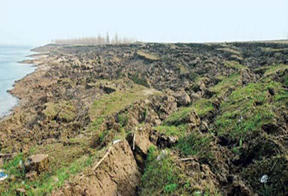
Figure 2-1: Bank collapse in Yueyang, 2006 Source: Photo by Jiahu Jiang
Since the erosion does not offset the loss of silt in the reservoir, the tidal wetlands in the Yangtze River Estuary around Shanghai have been eroding rapidly, ever since the Three Gorges reservoir began to fill in 2003 (Gleik, 2008). As a result, the Yangtze Delta is shrinking due to the abundance of sediment trapped behind the Three Gorges Dam (Yang et al., 2006; Chinese.WSJ.com, 2007; Gleik, 2008). Coastal ecological systems also suffer consequently. It is feared that Shanghai’s ability to expand will soon be limited by environmental degradation (Xu et al., 2006; Yang et al., 2006). In addition, agricultural production downstream from the Three Gorges Dam may also be adversely affected due to the systematic lack of nutrients-rich silt flow to fertilize the downstream farmlands (Xu et al., 2006). If sediment retention continues at this rate, it has been estimated that it will severely affect water quality and the various ecosystems in the Yangtze Delta upon which so much life depends (ibid).
2.3.4 Landslides and earthquakes
Landslides
Geoseismic conditions in the Three Gorges area are very complicated and problematic. Various geological disasters, such as earthquakes and landslides occur frequently (Ponseti & López-Pujol, 2006). Since the population density is very high within the dam region, even a moderate geological disaster in the reservoir area can cause an enormous loss of human lives and property (ibid). Among the ‘foreseeable side-effects’ of this massive dam project, one of them is the problem of landslide. Landslides and potential landslides generated as water levels in the reservoir have risen and declined seasonally. The likely case would be if the water level in the reservoir is high long enough for the water table in the adjacent slope to adjust accordingly to the high level (WWF, 2003; Ponseti & López-Pujol, 2006). Once the water level drops quickly according to the operation mode of TGP, the slopes of the side of the banks become unstable due to the pore pressure difference between the one in the saturated part of the side slope under the water and the top part of side slope above the new low water level which is exposed to atmospheric pressure (ibid).
Humongous amounts of water in the reservoir impose great pressure on the river bed, channels and banks. Water is forced to seep into the loose soil underneath and side-slopes of the reservoir, making the land destabilized and prone to slides. As a consequence, the soft material limestone base of the Three Gorges which is also layered with sandstone, mudstone and shale is prone to collapse due to this excess pore pressure (Ponseti & López-Pujol, 2006; Gleik, 2008; Highland, 2008). The soaking and increased pressure inevitably alters the hydraulic geological condition on the shoreline, causing unstable ground to weaken or give way. Therefore some sites in the Three Gorges region have started to show the signs of being unstable due to these changes in water loadings after the filling of the reservoir (Highland, 2008). The frequency of landslide occurrences is, as a consequence, more likely to increase than decrease, as was originally predicted. Soil and rock could easily cascade into the reservoir from a major landslide event, thus very likely causing the water level to rise by dozens of meters, which would in turn cause significant overflow to the surrounding areas (WWF, 2003). Geologists have warned that landslides could go on for at least another 20 years as the dam’s 175-meter-high reservoir continues to put pressure on the surrounding earth (Fu et al., 2010). As a result, the underground water continues to rise, thereby increasing dramatically the risk of serious landslides and even earthquakes as a result of the huge compensatory settlement of earth and water (WWF, 2003; Gleick, 2008; Highland, 2008; Fu et al., 2010). Moreover, the initial resettlement plan of upward migration partially contributed to the occurrence of landslides. As intimated above, the primitive methods of farming by local farmer involves clearing the land to plant crops, or to establish rows of orange trees. Along with deforestation, this type of ‘strip’ farming tends to lead to soil erosion, which then destabilized many hillsides.
All recent cases of documented scouring have significantly exceeded the annually average level before the construction of the TGD both in terms of quantity and intensity (Fu et al., 2010). Recently, officials and geological experts admitted that the TGD had caused more landslides than had ever been witnessed in decades (Xinhua, 2007a & 2007b). There have been 9,324 dangerous landslide sites identified during the whole period of the dam construction from 1994 to 2009 (Sheridan & Jones, 2010). And 2490 ‘slip masses’, 90 gullies and a total of 36 kilometers of shoreline have already collapsed as a consequence of mud-rock flows that have now been identified along the Yangtze and its tributaries (Highland, 2008). In Fengjie County, which is close to the TGD reservoir, for example, officials have currently identified more than 800 landslide-prone areas (Yardley, 2007). In some cases, large waves that reached as high as 50 meters caused by massive landslides around the reservoir cause even more damage (Gleik, 2008). More than 13,000 people have been forced to relocate since 2004 in fear of the landslides (Yardely, 2007).
For example, a more serious landslide occurred at the village of Qianjiangping on the Qinggan River, a tributary of the Yangtze with 3 kilometers away from their confluence, shortly after the water level reached 135 meters for the first time in the reservoir. On July 12, 2003, just one month after the filling of the Dam’s reservoir, a massive landslide of 24 million cubic meters of rock and earth slid into the Qinggan River, killing 14 people and causing another 10 to go missing, according to the official reports (Highland, 2008). And meanwhile, 4 factories, 300 homes, 22 boats, and more than 67 hectares of farmland were destroyed within a few minutes (Wang et al., 2004; Highland, 2008). The Three Gorges Office of Hubei province responded 3 days later by denying the correlation between the accident and the filling of the reservoir; instead, blaming the days of heavy rainfall in the area (Highland, 2008). However, the later investigations and surveys conducted by different institutes all confirmed that the filling of the reservoir was one of the main triggers of the accident (ibid).
There have been many other landslides accidents. For example, in 2007, 31 people died when a landslide on a tributary of the Yangtze River crushed a bus onto a mountain highway in Hubei Province’s Badong County (Stratton, 2007; Gleik, 2008). In April 2008, a large landslide and debris engulfed a primary school in Yichang, not far away from the dam site. Fortunately, there were no students or teachers in the school at the time (Three Gorges Evening News, 2008). On May of 2009, about 20,000 cubic meters of mountain mass collapsed into the Yangtze River near the northern bank of Wuxia Gorge, one of the Three Gorges in south-western Chongqing Municipality (ibid). A similar landslide occurred in the reservoir area in November of the same year, when about 50,000 cubic meters of rock and earth poured into the Yangtze, causing all water traffic to stop for two days (Yang, 2009). Although local Chinese officials, as always, quickly denied the connection between the landslides and the Three Gorges Dam downstream, the consecutive accidents raised serious concerns of the threats of geological disaster posed by the dam reservoir.
Even the central government has realized and acknowledged the threat. The State Council has approved a Chongqing development plan for 2007-2020 in which is included a resettlement of four million people from Chongqing to the city’s outskirts in October 2007 (Xinhua, 2007c; Peacehall, 2007a; 2007b; 2008; Yardley & Zhang, 2007; Three Gorges Evening News, 2008). The following explanation was given by the director of the Chongqing Development Plan Bureau: “Chongqing’s new development plan is to further our efforts to protect the environment of the reservoir area since the environment here has changed greatly due to the Three Gorges Project and massive population relocation” (Reuters, 2007; quoted in Webber, 2011, p.8).
Earthquakes
In addition to landslides, another and arguably the most serious threat to the structural integrity of the Three Gorges Dam and the people living around it is earthquakes, including reservoir-induced seismicity (RIS). The area surrounding the dam and reservoir had long been recognized as being seismically active, with numerous earthquakes in the past ranging from smaller than a magnitude 2 to greater than 4. Talwani (1997) claimed that several factors, including dam height, reservoir size, regional seismicity, the type of rock underlying the reservoir, and especially the orientation of local seismogenic faults all directly link to the magnitude of RIS (Talwani, 1997; Crampin et al., 2006; Highland, 2008). It is politically unsurprising that few people outside a small circle of professional people in seismology and the field of geodetics in China either realize, or are willing to acknowledge that the Three Gorges Dam is situated near six active fault lines (Highland, 2008). After the filling of the reservoir to 135 meters in 2003, low microseismic activity increased in several river sections of the Three Gorges reservoir (ibid). Williams (1993) has argued that the weight of the water alone in a large reservoir can trigger earthquakes. Chen and Talwani in a subsequent 1998 report pointed out that although the actual site of the Three Gorges Dam rests directly on a granite core, it is crucial to recognize that a 5 kilometers thick layer of soft limestone underlies the reservoir for well over 100 kilometers upstream of the dam (Chen & Talwani, 1998; Crampin et al., 2006). Given the fragile nature of limestone, the base of the reservoir is subjected to seismic instability, due largely to the fracture introduced by the earth vibrations (Zmolek, 1992; Barber & Ryder, 1993; Highland, 2008; Tullos, 2008).
Several studies completed even by conservative ‘party-line’ Gao et al. (1992), Li et al. (1993), Chen et al. (1994), and Su et al. (1996) concede that although big reservoir-induced seismicity episodes are unlikely, shallow seismicity earthquakes “might be occasionally induced” (Crampin et al., 2006, p.9). According to the Chinese Academy, seismic monitors around the reservoir and in Hubei Province experienced 3,429 tremors between June of 2003 (when the reservoir commenced storing water) and December 31, 2009. None of these was serious, but since the reservoir has reached its maximum height, the tremors have become worse (Martin, 2011). In a recent article in The Times (2010, May 30), it was revealed that within a six-month period of 2009, small-scale earthquakes have been recorded by Chinese authorities in the area around the dam and as far as 660 kilometers away in Chongqing. What is not made clear publically is that even shallow earthquakes can create the possibility of earth’s surface breaks, which are in turn likely to cause significant damage to the structure of the dam and reservoir (Crampin et al., 2006; Sheridan & Jones, 2010).
More serious seismic hazards occur when seismogenic faults induce cracks in the base of the Three Gorges Dam. Because the Three Gorges Dam is a concrete-faced dam (CFD), when the reservoir reaches its full height, the high water pressure behind the dam could quickly turn even the tiny cracks at the dam’s base foundation into big ones and is likely to cause water to escape (Crampin et al., 2006). It is predicted that this overflow could be sufficient to cause a tremendous loss of lives and property given the dense population which has settled in the flood plain along the river. At present the overflow threatens the flood security of quite a few cities on the banks of the Yantze River, possibly, the major industrial metropolis of Wuhan (Crampin et al., 2006).
Earthquake can also cause the collapse of limestone (karst) caves in the Wu Gorge and the abandoned coal mines in the Xiangxi Valley, making the area surrounding the Three Gorges reservoir seismically fragile (Highland, 2008; Reynolds, 2011). This instability makes the whole area particularly susceptible to earthquake-induced failure which can be rapidly magnified by even minor tremors such as this which suffer degraded geologic structure (Crampin et al., 2006; Reynolds, 2011).
For the sake of argument, let us accept, as mentioned earlier, that the Three Gorges Dam is designed to withstand earthquakes up to 7.0 on the Richter magnitude scale, and that the largest recent earthquakes have never been measured above 6.0 (Chen, 1999). However, when filled, the massive reservoir behind the dam would hold as much as 40 cubic kilometers of water, an almost incomprehensible weight, capable of creating enormous seismic pressures, and capable of triggering devastating earthquakes and landslides (Chen, 1999; Imhof & Lanza, 2010).
2.3.5 National Security Concerns
The remarkable size of the Three Gorges Dam body makes it a high-value military target. It is especially vulnerable should the potential terrorist attacks actually occur.
It has been widely revealed that according to an annual report from the U.S. Department of Defense about China’s military capabilities, the Department of Defense of Taiwan was considering targeting the Three Gorges Dam as a deterrent against possible insurgence or military coercion by the mainland Chinese government (U.S. Department of Defense, 2004; Gleick, 2008). Although the military leaders in Taiwan later denied that the Three Gorges Dam is a determined military target, the Taipei government explicitly suggested “acquiring weapon systems capable of standoff strikes against the Chinese mainland as a cost-effective means of deterrence”, according to the US report (U.S. Department of Defense, 2004; quoted in Gleick, 2008, p.146). Moreover, some top level Chinese military analysts have admonished that the Three Gorges Dam might become an easy target of terrorist attacks (U.S. Department of Defense, 2004; BBC, 2004).
Responding to the above remarks, the Vice General Manager of the China Three Gorges Project Corporation Cao Guangjing admitted that the corporation had already considered a wide array of terrorist scenarios and had taken measures to incorporate into the design phase of the dam several preventive engineering technologies designed to preserve the integrity of the dam in the face of a terrorist attack. As indicated earlier, the dam, for example, is alleged to be capable of withstanding an earthquake with a magnitude of 7.0 on the Richter scale. He added that the Three Gorges Dam was built as a concrete gravity dam which provides technological safety innovations of the highest quality. These engineering designs ensure that the dam will not be vulnerable to attacks using conventional weapons and the reservoir would be empty within 3 to 4 days if there were a nuclear attack (Xinhua, 2006a).
2.3.6 Compromising the Structural Integrity
China’s poor records on dam failure and negligence of dam maintenance do concern people with worries about the construction integrity of the Three Gorges Dam. According to one report, “Statistics and Preliminary Analysis of Incidents with Dams and Reservoirs in China,” more than 50 percent of China’s reservoirs built between 1950 and 1980 were constructed with low standards and poor quality building materials (Chetham, 2002). It is also estimated that one-third of China’s 86,000 dams are judged to have ‘serious’ structural problems (Lu & Shen, 2011). Those ‘ticking time bombs’ led to a total of 3,481 dam collapses of various kinds from 1954 to 2003, during the period of 1950 to 1980, an average of 110 dams collapsed each year (See figure 2-2) (Chetham, 2002; Lu & Shen, 2011).

Figure 2-2: Dam Collapses in China 1954-2000 (source: Infzm.com)
One of the worst disasters in China’s history, for example, was in 1975, when 62 dams in Henan province collapsed over one night during Typhoon Nina. Flood waves produced by the collapse of Banqiao dam on the Huai River (a tributary of the Lower Yangtze) killed an estimated 85,000 people, while another 145,000 people died due to resultant epidemics and famine for months thereafter (Topping, 1998; McCully, 2001; Chetham, 2002; Oster, 2007; Solomon, 2011a). This tragic incident was concealed for decades and only recently revealed (Oster, 2007).
Despite Cao Guangjing’s defense of the ability of the dam to withstand earthquake and conventional weaponry attack, there have been concerns about inadequate analysis of structural stability and the quality of building materials used in the TGD (U.S. Department of Defense, 2004; Gleick, 2008). In fact, according to a 2006 survey of the Three Gores region, 733 cracks which led to water leaking were found along both the channel banks of the ship lock (Solomon, 2011a). Although these cracks were subsequently repaired, the concerns about of the dam’s structural quality only increase with each new public the exposure of those problems. Interestingly, the necessary inspection and analysis of the dam to identify the potential cracking points and the according modifications of design needed to prevent this did not appear in the feasibility report conducted by the Canadian Yangtze Jointed Venture (CYJV). And the feasibility report also failed to “analyze possible failure modes such as rupture of the dam due to fault movement underneath it, and the performance of the dam during an earthquake with prior cracking” (Williams, 1993, p.141-142). Williams pointed out that the CYJV also underestimated the risk of spillway failure, which if it does happen, the remedial measures would be continual and costly (Williams, 1993; Barber & Ryder, 1993).
An inspection in 1999 revealed serious problems led to an investigation of one wall of the dam, due presumably to the use of inferior materials (Chetham, 2002). It is also a salutary reminder of what can happen if we are not vigilant in the protection of the dam. For example, 105 officials working on the Three Gorges Dam have since been jailed for embezzling construction funds by choosing cheap and inferior materials and equipment after the crackdown being investigated (ibid). This corruption and compromise of the engineering integrity of materials used has in fact resulted in infrastructure accidents. According to Chinese media reports, there was a total of 36 kilometers of reservoir banks caved in by the year 2006 and quite a few other places were found to have collapsed along the shore of the Three Gorges Reservoir (Allin, 2004; Xinhua, 2007a). Although it is to be conceded that there has been considerable strengthening and rebuilding of these poorly built structures, it is difficult to detect the extent to which the use of inferior materials has compromised the structural integrity of the dam as a whole. The old adage that ‘a chain is only as strong as its weakest link’ is apposite here. A report from the China Daily outspokenly pointed out the serious problems of the Three Gorges Dam, just as increasing numbers of professionals have at last openly addressed their concerns about the project (Xinhua, 2007a). “During the past three years, concrete placement in the project has not been first class, causing a variety of related accidents and drawbacks, though the concrete process has improved compared with previous years,” Ms Qian, former minister of Water Resources and Electricity Department was quoted (Liang, 2002). Some critics have expressed worry that a potential catastrophe similar to the aforementioned Banqiao Dam failure in 1975 is just waiting to happen.
2.3.7 Deterioration of Water Quality
According to an ecological and environmental monitoring report issued by the State Environmental Protection Administration (SEPA) in 2006, three years after the Three Gorges Reservoir was filled in 2003, results of monitoring the water quality of the Yangtze River near the reservoir area indicated that it was of sufficient quality to meet grade II and III (grades I–III are suitable for drinking) (SEPA, 2006; Li, 2007; Wong, 2011). Therefore a reliable quality of drinking water can be assured from this part of the reservoir. However, the water quality was much worse in surrounding tributaries of the Yangtze, because the Dam is retaining the upstream waste (SEPA, 2006; Oster, 2007). The relatively low speed of the water flow allows pollutants such as waste sewage, chemicals, and other contaminants that previously were diluted and flushed down river into the sea by the fast-flow to collect behind the dam (Chathem, 2002; Ponseti & Lopez-Pujol, 2006; Hu & Cai, 2006; Reynolds, 2011). This being so, pollutants tend to get backed up into tributaries, slowing the tributary flow and in turn changing the composition of water chemistry and biology (Oster, 2007). Pollutants such as total phosphorus, total nitrogen, dissolved silicate (SiO2), and chlorophyll have contaminated that water, due to the change of land-use and management mode (Ye et al., 2006). One particularly invidious example is the high levels of pollution caused by the increased use of chemical fertilizer in the reservoir area from 1996 to 2007. This form of water toxicity has led in turn to the proliferation of algae (Liu et al., 2006a; Huang et al., 2006; SEPA, 2009; Fu et al., 2010; State Council, 2011).
The sources of water pollutants in the Three Gorges regions are diverse. These sources include urban waste, industrial and agricultural waste, waste treatment plants discharge, shipping, and contaminants carried by toxic imports through trade or manufacturing processes (Liu & Qu, 2004; Okader et al., 2006; Fu et al, 2010). Over 1,300 factories and abandoned mines, along with some 40,000 graveyards and approximately 200 waste dumps, have all been submerged when the dam was completed in 2009 (Sutton, 2004; Ponseti & Lopez-Pujol, 2006). Health experts warn that toxins released from those sources into the water will create a long-term hazard for people and the animals that depend on the river for survival (ENGR). Statistics indicate that there is approximately 1.35 billion tons of sewage dumped directly into the Yangtze annually (CTGPC, 2010) without being properly treated. This was partially due to the insufficient funding for building up new waste treatment projects (Ponseti & Lopez-Pujol, 2006). If effective and drastic measures are not taken, the long river even like the Yangtze will gradually lose its capacity of self-cleaning and self-regulating (ibid). Another major concern is a 30 meters high polluted belt created by the differences in the water level in the reservoir due to the operation mode of the Three Gorges Dam (Highland, 2008). In the dry winter months the height of the reservoir is 175 meters, while in summer flood season it drops to 145 meters (ibid). As we have observed, this 30 meters high wide ring around the banks of the Three Gorges reservoir and further along the upstream tributaries could become “geologically unstable, seriously polluted and a dangerous source of epidemic disease” (Su et al., 2003; New & Xie, 2008; quoted in Highland, 2008, p.13). Moreover, since this strip provides good farmland for local farmers when the water recedes, the chemical fertilizer and pesticides used on this strip simply leach into the river when the water rises in winter, posing a serious pollution problem (Chen et al., 2001; Xu et al., 2006).